Uber Morphology, Beach Restoration and Native Fisheries
Fulfilling a hydrologist’s dream, I recently spent 21 days of April floating through the “Big Ditch”, aka the Grand Canyon, generally getting my mind and body altered by the scale of just about everything. The way canyons and waterways form and continue to change both violently and incrementally. How to keep my body from not becoming a carcass. Seeing the grain-by-grain scalloping of the 1.7 billion year-old black Vishnu Schist and contemporary massive side-canyon fluvial blow-outs and landslides. The regulated flow regime that reminded me more of tidal rhythms of oceans rather than the flow of a river. A complete disruption of sediment transport through the canyon continuity courtesy of the Glen Canyon Dam. In all, quite a palate of goodies for a process hydrologist to experience, digest and wonder upon.
The Sediment Starved River
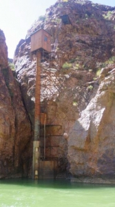
With the completion of Glen Canyon Dam in 1963 the Colorado River in the Grand Canyon was, for the first time, significantly changed by humans on a scale that emulated geologic forces. At a height of 853 feet, the dam competes with pre-historic lava dams in the canyon which were up to 2,000 feet high. When a river is dammed and becomes a lake, things change downstream of the dam. For example, prior to dam construction the Colorado transported approximately 91 million tons of sediment per year while today that number is a paltry 14 million tons/year, imported to the river exclusively from side canyons. (Prior to the dam, the Colorado River had the distinction of being the muddiest river in the United States, with runoff ratios of 40% sediment and 60% water. (That is basically viscous sludge).
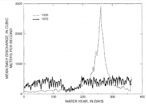
In addition to sediment starvation, flow regulation at the dam converted frequent 100,000+ cfs spring runoff flood events to an almost monotonous 12,000 to 25,000 cfs (Figure 1 and Figure 2) high flow regime with no semblance of natural process. Sediment transport and deposition dynamics are directly tied to high flow events and the contemporary hydrograph looks more like a tide table than a natural river hydrograph.
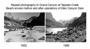
With this set-up, the Grand Canyon’s fabled beaches began to disappear along with the ecologically vital and dynamic riparian communities associated with them on the channel margins. (Figure 3). Rapid erosion of the once ubiquitous sand beaches was first noted in the 1970’s, a mere 10+ years post-dam. In addition to vital river habitat the sand bars provided magical camping sites for floaters and hikers while also being a dynamic riparian and channel margin ecosystem – a ribbon of oasis green in an otherwise largely unforgiving desert environment.
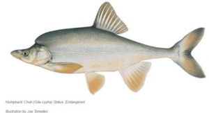
Native fish also began to struggle with the cold clear water discharged from Lake Powell and the consequent invasion of non-native predatory trout. Native residents including the endangered Colorado humpback chub, (Figure 4), and the razorback sucker populations plummeted and receded to small niche habitats and also faced new non-native parasites and a radically re-designed food and shelter situation.
Efforts to Mitigate Impacts of Beach Erosion
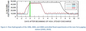
Beginning in 1996 river managers began experimenting with artificial flood regimes to increase sandbar volume and area, natural riparian recruitment and native fish habitat. The 1996 experimental flood event resulted in a net increase in bar volume and height and was believed to be a function of entraining sand on the channel bed and depositing this sand in eddies, creating sand bars. The experiment was repeated in 2000, 2004 and 2008 with a reduction in total period of time at peak releases (Figure 5). Beginning in 2012 river managers committed to continued experimental flooding through the year 2020.
So, what is the current consensus on the efficacy of the experimental floods? The most recent literature I reviewed suggests a big question mark. While there is bar accumulation during these artificial flood events, the rapid drawdown associated with these releases has left behind bars with very steep bar faces that are vulnerable to scour and undermining by flows above 15,000 cfs. My personal observation of the bar forms I floated by and camped on is that the experiment isn’t working – one simply cannot overcome the loss of sediment stored in Lake Powell. Simply trying to redistribute sand on the channel bed to side-channel bars is not a long-term solution and in fact a losing proposition.
Further, monitoring of these events indicate no measurable gains in riparian health and density or native fish habitat.
Other means of bar augmentation that have been investigated include dredging sediment from Lake Powell and delivering it via pipelines below the dam. While conceptually appealing at first blush, the reality is the infrastructure and cost of such an effort would be prohibitive much less actually being able to make a dent in the river’s appetite for sediment. Unless the dam is decommissioned, (which actually has many proponents, including water users, environmental groups and recreationists), I foresee future experimental floods a marginal effort to put a bandaid on a hemorrhaging artery.
Riparian Restoration Attempts
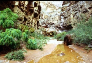
With the significant dampening of peak flows post-dam the river’s riparian communities were also dramatically altered. The old high water line species went into significant decline and areas below this line became prime habitat for the incredibly invasive and hardy tamarisk, (also known as salt cedar, Figure 6). Tamarisk appeared in the Grand Canyon in the late 1920’s and went into full-on siege mode in the post-dam period to become the dominant riparian plant. Highly effective at hoarding light, space, water and nutrients, tamarisk provides very little in the way of ecosystem services, i.e. supporting the native bugs, birds, reptiles, mammals and fish.
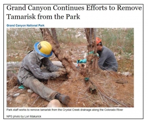
Beginning in 2002, US Park Service restoration biologists began experimenting with tamarisk eradication methods under the assumption that if they could be knocked back, (eradication not considered remotely possible), native riparian shrubs could re-colonize (Figure 7). Efforts to mechanically remove, cut, girdle along with herbicide applications began on sand bars determined to have the highest potential for native re-colonization. These efforts proved marginal as tamarisk is extremely prolific and can rapidly re-invade spaces opened by removal efforts. Then in an unexpected situation, tamarisk biocontrol efforts from 200 miles away made an appearance in GCNP in the form of the non-native tamarisk beetle which had been let loose in other agency efforts to control tamarisk along the Colorado River in Utah. While the beetle has been found to help defoliate tamarisk, it is not clear this will lead to plant mortality, with some suggesting it may be 20 years before an individual tamarisk succumbs, if at all.
The ecological literature on the topic suggests that rather than eradication a form of reconciliation may be the most appropriate management strategy into the future. Reconciliation is a landscape resiliency theory that posits we are now in an era of human- and climate-induced landscape conditions that cannot be “restored” to a previous condition or maybe even “mitigated”, so we need to learn to adapt. An emerging consensus is that now is the time to continue experimenting with “farming” riparian areas in an effort to increase desirable species while holding undesirable species such as tamarisk at bay.
Fisheries Restoration Efforts
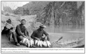
The humpback chub evolved around 3-5 million years ago and is one of five regional endangered populations. The Lower Colorado River Basin in the Grand Canyon has the largest population of about 7,650 individuals, a mere fraction of historic numbers – the humpback was the first canary signaling distress in the new post-dam river mine. Placed on the endangered species list in 1967, active population monitoring has occurred since 1987.
Recovery strategies being tried include a fish trap at Bright Angle Creek, (Phantom Ranch area), where adversely predatory and non-native brown trout are being removed by weir trapping along with trying to suppress rainbow and brown trout numbers in the “Lee’s Ferry Reach”, much to the consternation of trout anglers.
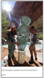
Agency fisheries biologists have also been experimenting with translocating juvenile chub captured near the Little Colorado River to suitable tributaries such as Shimuno and Havasu Creeks (Figure 9). Per the USPS, “Tributaries were evaluated on the basis of water quantity, temperature, flow, fish barriers and proximity to the reaches of the Colorado River where wild humpback chub are found.” The strategy is to establish “genetic reservoirs” of the native fish in previously unoccupied habitat to enhance the long-term survival of at least a minimum sustaining population. This strategy has proven at least partially(?) effective with a number of native fish species throughout the Western US, including native Colorado cutthroat in the Upper Colorado Basin in Wyoming.
Humpback chub monitoring indicates a declining population between 1989 and 2001 and then on a more positive note, a 50% increase in the period 2001 and 2008. Let us all hope current management efforts continue to coincide with increasing populations.
And Finally, Mind-bending Geomorphology
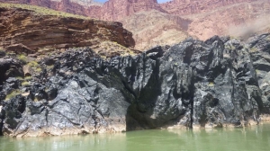
Before I entered the “Big Ditch” I was “warned” by my fellow professional river geeks that I was going to have a fluvial re-baptizing. This proved more than true. I barely know where to start outside of saying – “WOW. I am not worthy, oh great Fluvial Gods and Goddesses”. Take the concept of the 1.7 billion year-old basement rock Vishnu Schist (Figure 10), infinitesimally eroding at the bottom of the ditch, combine that with zillion year old and current landslides and side canyon sludge hoses puking boulder and debris fans on a regular basis today (Figure 11 and 12). And did I mention the historic lava dams and 6 oceans that came and went in what is now the Grand Canyon (Figure 13)? And zillions of years of erosion and uplift and streams pouring out of limestone walls (Figure 14)?
The world’s foremost geology geeks are still arguing, debating, and theorizing on what processes actually unfolded. It is still a mystery and I find that intellectually fitting – we don’t and won’t ever know everything with certainty. This adds to the grandness of the Grand Canyon.
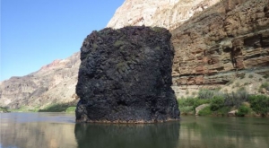
So as not to break my brain and have some reserves for my pending and post-Crystal Rapid “swim”, (where I was a tiny speck of sediment in the clutch of the indomitable will of the river – talk about humility!, Figure 14), I focused on what I know best, which is interpreting current riverine conditions. I could write a whole piece just on this amazing experience.
Other images I hold: large logs perched on house-sized rocks in the river 20 feet over my head; complete side canyon explosions with car-sized boulders as bedload; layers and layers and layers of flood event debris dating from 2 years ago and back to the Pleistocene; the mighty Colorado River eating these debris delta’s up if not distributing the load to better flavor the Class IV rapid the fan created; imbricated bars 10 feet off the deck composed of 2 foot diameter boulders. It was basically sensory overload but had a theme: that this is one powerful place and the rule of water + gravity = erosion prevail on the grandest and most subtle of scales, since the beginning of time until now.
Parting Thoughts
While floating the Grand Canyon was a non-professional bucket list item I couldn’t help being curious about the approaches natural resource managers and academics were facing today to “reconcile” ecological and functional objectives with the completely new playing field in the aftermath of Glen Canyon Dam. On whole I am supportive of the experimentation and adaptive management process that are being explored.
The Grand Canyon humbles all small efforts and half-measures– it is vast, remote, and unbelievably powerful. It is also now separated from natural rhythms and cycles it enjoyed up to my 1st birthday in 1963 when the dam was completed. Breaking the river literally happened on my watch.
I leave this thought with a quote from Edward Abbey, whose writings I devoured as a teen and young man exploring the desert Southwest.
“What do we know? What do we really know? He licks his dried cracked lips. We know this apodictic rock beneath our feet. That dogmatic sun above our heads. The world of dreams, the agony of love and the foreknowledge of death. That is all we know. And all we need to know? Challenge that statement. I challenge that statement. With what? I don’t know.”Edward Abbey, The Monkey Wrench Gang


